This has something to do with photography

silvercreek

Senior Member
I like using Google Earth and find it fascinating every time I use it. What I've always wondered is, how do they take the street level pictures? Those can't possibly be from the satellite view and I know there are not thousands of photographers running around taking pictures on every street in every city. You can see people on the sidewalks, delivery trucks and kids riding their bikes.


HOW ON GOOGLE'S EARTH IS THAT DONE?
 
Last edited:

Rick M

Senior Member
I think it is all satellite. Over time they hit a lot of angles creating the 3D image. Since many of the veiws are old, it's a compilation over time.
 

ABN Panzer

Senior Member
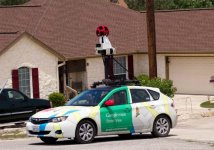
If you are talking about streetview... they have a mast (360 view/camera set up) attached to the top of a car that drives along the road. We have a blue Dodge-Omni in our area that I had seen twice and finally asked him what the set up was. His car was marked as a Google-Maps research vehicle. he stated he just drove around and the computer/gps/cameras did the rest.
 

fotojack

Senior Member
Absolutely right, ABN. I did the same thing when I saw this Google car with the mast on top. I asked the guy what he was up to and he told me that's how they get the street shots you see on Google maps. Pretty cool job when ya think about it. :)
 
I have seen the Google Photo car in action near where I live here in Jacksonville, FL.
Google-Earth-Car.jpg
 

Marilynne

Administrator
Staff member
Super Mod
Contributor
If you are talking about streetview... they have a mast (360 view/camera set up) attached to the top of a car that drives along the road. We have a blue Dodge-Omni in our area that I had seen twice and finally asked him what the set up was. His car was marked as a Google-Maps research vehicle. he stated he just drove around and the computer/gps/cameras did the rest.

I've seen the van's shadow in a couple of shots when looking up an address.

 
Top