New Approach (For Me) For Geotagging

Eduard

Super Mod
Staff member
Super Mod
Over the years, I have used many different GPS devices with my cameras. (You can see the evolution here.) My wife and I are leaving in a couple days for a quick trip to Europe. I'm going to try a new approach to Geotagging which I'll discuss below.

She is going to use my V2 and 10-100mm instead of her P&S. She wants it to be as small as possible so adding the GPS will be a no-go. I'll have my D800. The AK-4NⅢ works great but due to the side extension on the Tamron 24-70/2.8, has to be removed during lens changes. Taking these two issues as input, I decided to look for a new solution that would work for both cameras.

I remembered @Don Kuykendall's post about Geotagging with iPhone software. I wound up testing Geotag Photos Pro for my iPhone. I was very impressed at how easy it integrates with Lightroom. I screen captured this representation of the workflow from the vendor's website:
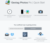
Screen Shot 2014-11-16 at 3.27.46 PM.png

Problem solved? Not quite. I ran into an unexpected issue. When in Europe I turn my iPhone to airplane mode to avoid roaming charges. The iPhone will not provide GPS signals in airplane mode. Android phones do not have this limitation.

One of my buddies is a big-time Android user. I explained my problem and asked him for a recommendation for a low-end Android phone that might meet my needs. He handed me his wife's old Nexus One that is jailbroken and rooted. I installed the Android version of Geotag Photos Pro on the phone. The software works perfectly - and I don't even have a SIM card installed in the phone. Score!!!

Can't wait to give this a real world test. I'll post an update mid-trip and let everyone know how it is working out.

Here is a quick video on how to use this solution with Lightroom:

 
Last edited:

480sparky

Senior Member
How so? Have you only used the Lite version? Any difference with the Pro version?

I can't speak for the Pro version, but I doubt the way it works is any different that the Lite. There's no reason to create two totally separate processes, making the free version crippled by somehow corrupting files, but paying them will make it go away.
 
Last edited:

RocketCowboy

Senior Member
@Eduard, what if your iPhone was on and not in airplane mode, but had the SIM removed? You wouldn't have to worry about roaming charges, but I'm curious whether the cellular radio would activate without a valid SIM or not. I may try this with one of my previous iPhones, since that's usually what I activate (through T-Mobile, much cheaper international roaming rates) when traveling abroad.
 

Jerry_

Senior Member
Did recently a test on an iPad (thus to be checked if all applies to the iPhone, too) by deactivating the 'Cellular data' and the 'Wifi' as well.
With those two deactivated (and not being in Airplane mode) the GPS worked.

So there are chances that it could work without a SIM card.
 

Eduard

Super Mod
Staff member
Super Mod
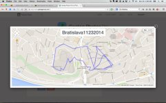
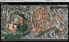
Back from my trip and I have to say this solution worked brilliantly. This approach greatly simplifies using multiple cameras as well. Very glad I made the change. Here are a couple interesting screenshots that may be useful for those still on the fence. This is from one day in Bratislava.

View from geotagphotos.net:

Screen Shot 2014-11-30 at 4.38.06 AM.jpg

View from Lightroom:

Screen Shot 2014-11-30 at 4.34.35 AM.jpg
 

cwgrizz

Senior Member
Challenge Team
Eduard, I have been following this thread and thanks for the followup. I do not GeoTag my photos usually, but I had a plan for a method. I already have a GPS and I had planned to use it for geotagging photos when desired. My method was going to be as follows:

1. Take a picture of the clock on the GPS when starting the daily hike and have the GPS set for tracking
2. At the end of the day download the pictures and the GPS tracking to the computer
3. Use the software Geosetter to marry the pictures to coordinates along the path.
Geosetter will allow for adjusting the time difference in time on the camera and the GPS. That is the reason for the initial picture of the GPS clock.

This is simplified, but it gives the general idea. Some out there may have a GPS and not a smart phone. I know, probably not likely, but................who knows. Ha!

Also, data & roaming charges would not be a concern.
 

RocketCowboy

Senior Member
Eduard, I have been following this thread and thanks for the followup. I do not GeoTag my photos usually, but I had a plan for a method. I already have a GPS and I had planned to use it for geotagging photos when desired. My method was going to be as follows:

1. Take a picture of the clock on the GPS when starting the daily hike and have the GPS set for tracking
2. At the end of the day download the pictures and the GPS tracking to the computer
3. Use the software Geosetter to marry the pictures to coordinates along the path.
Geosetter will allow for adjusting the time difference in time on the camera and the GPS. That is the reason for the initial picture of the GPS clock.

This is simplified, but it gives the general idea. Some out there may have a GPS and not a smart phone. I know, probably not likely, but................who knows. Ha!

Also, data & roaming charges would not be a concern.

I have used GPS tracking logs from a couple different Garmin GPS units (handheld and motorcycle mounted) to geotag images coming off my point and shoot cameras. Worked great when I had the GPS with me while traveling, but since getting into DSLR photography I don't usually have one of those with me. BUT ... I always have my phone. Great to have multiple options though, and particularly when they are cheaper and/or work better than having something built into/for the camera body itself.
 

SteveH

Senior Member
On Android, I use MyTracks - Its free and is primarily a digital pedometer recording your maximum speed, average speed, inclines & descents etc as well as calories burned and time stood still. It is designed for walking, running, cycling, horse riding etc and you can export the recorded tracks in various formats including GPX, and upload direct to Google maps.

If you are into your hikes and bike rides mixed with photography, it is well worth trying.
 

RocketCowboy

Senior Member
Reviving an old thread ...

I started testing with this today on my iPhone 6. Tomorrow I'll do a quick test with my older iPhone 5 which has no cellular service, just to validate that the GPS works. I'm expecting it will, since I use RunKeeper on the same iPhone to track my bicycle rides, but will verify tomorrow.

For the images captured today, looks like the geotagging worked just fine.
 
Top